2011年12月31日土曜日

Modern Architecture in Japan, Saga town of Koto ward, Tokyo

Saga Town Studio
Entrance of Saga Town Studio
Sanuki Syokuhin
Kosuga Limited Company
(English)

Saga town of Koto ward, Tokyo was located at the west side of the area of Eitaiji temple and Tomioka Hachimangu shrine. And Eitaibashi bridge connected with the center of Saga town.

Saga town was along with Sumidagawa river so that it was a water transport town and had many warehouses.

After Edo period, Meiji, Taisho and Showa before the world war two, Saga town still kept as a water transport town and prospered.

Firebombing of Tokyo did not reach Saga town. So Saga town has some modern architectures as shown. The building shown in the first and second pictures was a warehouse company built in 1928. Now it is used a studio.

The buildings shown in the third and forth pictures are other modern architectures.

(Japanese)

江東区佐賀町は、永代寺と富岡八幡宮のすぐ西に位置し、又、当時の永代橋は現在より少し北側、佐賀町の真ん中に架けられていた為、永代寺や富岡八幡宮に参拝や観光に訪れる江戸庶民によって、賑わっていた。

川沿いに立地する多くの町がそうであったように、佐賀町も又、水運で栄え、多くの蔵が立ち並んでいた。

江戸時代が終わり、明治、大正、戦前まで、佐賀町は水運の町として栄えた。東京大空襲を奇跡的に逃れた佐賀町には、幾つかの近代建築が残っている。写真のビルは、1928年(昭和3年)竣工の、嘗て、倉庫業を営んでいた会社のものだ。今は、スタジオとして使われている。

他の2枚は、同じく佐賀町にある近代建築。


2011年12月29日木曜日

One Hundred Famous Views of Edo by Hiroshige Utagawa, Spring No. 12 "Ueno Yamashita"

Present view
Painted by Hiroshige in 1856
(English)

This print shows the prosperity of the are in front of Ueno Kaneiji gate. Iseya which was famous as a perilla rice restaurant, Gojo Tenjin shrine, the stone wall of Ueno Kaneiji temple and the cherry-blossom viewing party with parasol were drawn. Ueno was located along with Nikko Onari Kaido and had Ueno Kaneiji so that Ueno prospered very much.

Now, Iseya was failed and removed. In stead of that, there was a karaoke studio. But Ueno makes us feel Edo still.

(Japanese)

この絵は、上野寛永寺門前の賑わいを描いたもので、紫蘇飯で有名だった伊勢屋、五條天神、上野寛永寺の石垣、上野の山に花見に来た御一行様を描いている。上野は、日光御成り街道沿いに位置し、徳川家菩提寺の上野寛永寺を控え、非常に賑わっていた。

今の上野だが、伊勢屋は無くなりその代わりにカラオケ屋が建っている。しかし、ここ上野の賑わいは当時のままだし、江戸情緒を感じさせてくれる良い街だ。

Map made in 1858


より大きな地図で 上野山した を表示

2011年12月26日月曜日

One Hundred Famous Views of Edo by Hiroshige Utagawa, Spring No. 11 "Kiyomizu Hall and Shinobazu Pond at Ueno"

Present view
Painted by Hiroshige in 1856 - 1858
(English)

This print shows Ueno Kiyomizudo temple and Shinobazunoike pond. Ueno hill was developed in 1625 to build Kaneiji temple. Kaneiji was a Tokugawa family temple. So Kaneiji had a very large site which was 100 ha and had 36 sub-temples. Kaneiji was built imitating Enryakuji temple. Ueno Kiyomizudo temple imitates Kiyomizudera temple at Kyoto. And Shinobazunoike pond imitates Biwako lake.

In 1632, cherry trees were planted. Since that, Ueno hill was a famous place to see cherry blossoms.

Many buildings were destroyed by fire by Ueno war which happened in 1868. But Shinobazunoike pond and Ueno Kiyomizudo temple were miraculously left.

(Japanese)

この絵は、上野清水堂越しに不忍池を俯瞰したものである。上野の山は、1625年(寛永2年)、寛永寺創立の為に開かれた。寛永寺は、徳川菩提寺の一つで、100haの敷地、36の子院をという、非常に大きな勢力を持っていた。寛永寺は、江戸城の鬼門に位置し、京都における比叡山の位置付けにすべく、開発された。よって、『東の叡山』の意で、東叡山 寛永寺と名付けられている。 不忍池は琵琶湖、上野清水堂は清水寺を模して、作られている。

上野の桜は、1632年、林羅山により植えられた。それ以来、上野の山は桜の名所である。

上野戦争により、寛永寺の多くの建物が焼失した。が、清水堂は。奇跡的に当時のまま残っている。

Map made in 1858


より大きな地図で 上野清水堂不忍ノ池 を表示

2011年12月23日金曜日

One Hundred Famous Views of Edo by Hiroshige Utagawa, Spring No. 10 "Sunrise at Kanda Myōjin Shrine"

Present view
Painted by Hiroshige in 1856 - 1858
(English)

This is the print which is drawing sunrise at Kanda shrine on new year's day. Kanda shrine was located on the east edge of Hongo tableland. Therefore it was a famous place to see sunrise.

Kanda shrine was originally established in 730 at Ote-machi, Chiyoda-ku, Tokyo. In 1616, Hidetada Tokugawa who was the second shogun of Edo moved it here to protect Edo. Here, Kanda was located at the northeast of Edo castle. Northeast was the direction of the demon's gate in Feng shui.

Now, Kanda shrine is still here. But buildings obstructs to see sunrise.

(Japanese)

この絵は、神田明神境内から、『曙』つまり、日の上がる方角、東を望んだ絵である。時期は元旦、神田明神で初日の出を拝み、初詣し、と、いう絵である。神田明神は、本郷台地の東の端に位置しており、東側は東京低地、ずっと先まで見渡せた。人気の初日の出スポットだったのである。

神田明神は、天平2年(730年)、出雲氏族で大己貴命の子孫・真神田臣(まかんだおみ)により、武蔵国豊島郡芝崎村、現在の東京都千代田区大手町・将門塚周辺に創建された。その後、元和2年(1616年)、2代将軍秀忠により、江戸守護の為、表鬼門に当たるこの地に、環座された。

今の神田明神は、まだそこにある。が、東の方向は、ビルが立ち並び、眺望は無い。わざわざ、『曙』に合わせ、冬のとある朝、いつもより少し早く出勤し、7:00頃に訪れたのだが・・・

Map made in 1858

Topographic map


より大きな地図で 神田明神曙之景 を表示

2011年12月22日木曜日

One Hundred Famous Views of Edo by Hiroshige Utagawa, Spring No. 16 "Flower Park and Dangozaka Slope in Sendagi"

Present view
Painted by Hiroshige in 1856 - 1858
(English)

This is the print drawing "Sendagi Hana Yashiki" meaning Sendagi Flower Garden. The foreground pond, the cherry trees, the mansion on the hill, all of them were Uheiji's property. Uheiji was a gardener. Yes, he was a JUST gardener.

In Edo period, originally and basically there was hierarchy of samurai, farmer, artisan and merchant. But in the later half of Edo period, in the real world, merchants had power. And gardening was very popular so that Uheiji could have this garden.

Now, the Dangozaka slope which is shown at the center of the print is still here. But the others were completely removed. I'm very sorry about that. If...yes, I know I have to accept. But if...

(Japanese)

この絵は、団子坂上にあった、千駄木花やしきを描いたもので、画面上部に描かれているのは紫泉亭という茶屋、手前の池はこの花屋敷内の池、間の桜並木ももちろん花屋敷のものだ。

この花屋敷は、宇平次という一植木屋が作ったものだ。『ただの』植木屋が。当時、すっかり平和になった江戸では、ガーデニングが大人気で、この辺りは植木屋が多く、休日の良い遊び場所だった。宇平次も、相当に儲けたのだろう。

今のこの辺り、団子坂はまだ残っているものの、その他は全て無くなってしまった。地形が変わっていないので、特に団子坂が登りながら左に曲がっているところなんかは、雰囲気が残っているが、それにしても、桜が残念である。

Map made in 1858


より大きな地図で 千駄木団子坂花屋敷 を表示

2011年12月21日水曜日

One Hundred Famous Views of Edo by Hiroshige Utagawa, Autumn No. 93 "Mokuboji Temple and Vegetable Fields on Uchigawa Inlet"

Present view
Painted by Hiroshige in 1856 - 1858
(English)

Here, the place which Sumidagawa river and Ayasegawa river meets was called "Sekiya no sato" meaning Sekiya village. At Sekiya no sato, there used be the palace for Tokugawa shogun before Sekiya no sato. The palace had the beautiful garden and a truck farm dedicated for Tokugawa shogun. And after the Tokugawa shogun palace was removed, the garden and farm were left. Then they were very popular for Edo people as a resort.

Now, there is Higashi Shirahige Park. The inlet of Sumidagawa river which is drawn in the Hiroshige print was reclaimed. The farm was removed. The park is not bad but I prefer Sekiya no sato.

(Japanese)

ここ、隅田川と綾瀬川の合流部、隅田川東岸部は、嘗て、徳川将軍家の隅田川御殿があった。隅田川御殿はその後撤去されたが、庭や御栽畑はそのまま残り、関屋の里と呼ばれ、江戸庶民のリゾート地となっていた。

今は、東白髭公園となっている。隅田川の入り江は埋め立てられ、畑は無くなった。東白髭公園もなかなか良い公園だ。特に桜の季節は良いだろう。が、私は、関屋の里の方が良い。

Map made in 1858
より大きな地図で 木母寺内川御前栽畑 を表示

One Hundred Famous Views of Edo by Hiroshige Utagawa, Spring No.20 "The Kawaguchi Ferry and Zenkōji temple"

Present view
Painted by Hiroshige in 1856 - 1858
(English)

The Kawaguchi Ferry connected Kawaguchi station and Akabane station. Kawaguchi station and Akabane station were the stations on Nikko Onari Kaido which Tokugawa shoguns used to visit Nikko Toshogu.

Edo people believed that to go to Sukhavati, they had to visit Shinano Zenkoji temple which had a statue of Amida Nyorai (Amitabha Tathagata) once in all their life. But Shinano Zenkoji temple was far to visit.

Kawaguchi station had Kawaguchi Zenkoji temple which had a statue of Amida Nyorai (Amitabha Tathagata). Edo people believed that to visit Kawaguchi Zenkoji temple was same effective as Shinano Zenkoji temple. So Kawaguchi Zenkoji was very popular and Kawaguchi Ferry was crowded.

Now, many things has changed but Kawaguchi Zenkoji temple is still here. You can see it on the upper right corner of the photo (Same position as Hiroshige print). It has the bronze color roof.

(Japanese)

川口の渡しは、川口宿と赤羽宿を繋ぐ渡しで、日光御成街道にあった。将軍家が日光東照宮にお参りする際は、混雑し警備上の問題が懸念された日光街道を使用せず、この、御成街道を使用した。

江戸の人々は、極楽浄土に行く為には、信濃善光寺に一生に一度はお参りしなければならないと信じていたが、唯一の交通手段が徒歩だったこの頃は、お参りは簡単ではなく、同じ阿弥陀如来を祀っていた川口善光寺が人気だった。川口の渡しも、御開帳の日は大変な賑わいだった。

川口善幸寺は、今もそこにある。広重の絵では画面右上に描かれているが、写真でも同じ位置に捉える事が出来た。

Map made in 1880


より大きな地図で 川口のわたし善光寺 を表示

2011年12月18日日曜日

One Hundred Famous Views of Edo by Hiroshige Utagawa, Autumn No.92, "In the Akiba Shrine at Ukeji"

Present view
Painted by Hiroshige in 1856 - 1858
(English)

Here, at Ukeji, there is Akiba shrine. Akiba shrine is believed the power of protection against fire. Edo had many fires so that Akiba shrine was popular.

Akiba shrine had a large site. It had a pond, an artificial hill and was a beautiful garden.

Mukojima which Akiba shrine was located was popular for Edo people because of that to reach Mukojima, they had to cross Sumidagawa river and this crossing Sumidagawa river made Edo people feel unusual and something special.

So many people visited Mukojima and Akiba shrine.

Now, Akiba shrine is still here but its size of the site shrunk.

(Japanese)

請地とは、今は使われていないが嘗てのこの辺りの地名で、そこには秋葉神社があった。秋葉神社は火除けの神で、江戸は火事が多かったことから、人気があった。

秋葉神社は当時、広大な敷地を持っており、そこには、池や築山が配置され、非常に美しい庭園だった。

向島は、江戸庶民にとって非常に人気のリゾートだった。徒歩で日帰りで行ける距離にあり、それでいて、向島に行くには隅田川を渡らなければならないが、この、隅田川を越える行為が、日常から非日常への切り替えスイッチのような働きをし、人々の心をワクワクさせた。

だから、秋葉神社には、春の桜の季節、秋の紅葉の季節は特に、多くの人が訪れた。

今の秋葉神社だが、当時と同じ場所にある。が、敷地は大きく縮小され、池は埋め立てられ、築山は削られて、嘗ての庭園部分は、壊滅状態である。

写真は、嘗ての池跡地で撮ったものだが、うらぶれて寂れた、一日中日の当らないような場所にあり、嘗ての秋葉神社をご存じの方なのか、かろうじて、一本だけ、紅葉が植えられているだけで、何とも寂しい限りだった。紅葉の向こうの白い建物は、トイレである。

秋葉神社も写真に収めたが、見ての通り、参道は、R6でぶった切られ、且つ、場末の飲み屋への参道となっている。

あまりにも寂しいので、なんとか秋葉神社の面目を保てるよう良い構図を探し、歩き回った。

Main gate view...sad
With ginkgo
With Japanese maple

Map made in 1858


より大きな地図で 請地秋葉の境内 を表示

2011年12月13日火曜日

One Hundred Famous Views of Edo by Hiroshige Utagawa, Spring No. 7 "Shops with Cotton Goods in Ōdenma-chō"

Present view
Painted by Hiroshige in 1856 - 1858
(English)

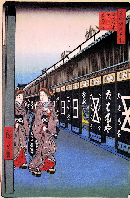
Odenma means big denma. Denma means post-horse.

The street 2 ladies are walking was Nikko Kaido and Oshu Kaido of Edo Five Routes. Edo Five Routes like Nikko Kaido and Oshu Kaido needed post-horses. So Ieyasu Tokugawa who is the first shogun of Tokugawa housed government officers of post-horse in Odenma.

Odenma developed with the prosperity of the streets. A government officer of post-horse was Kageyu Magome. Kageyu Magome came from Mikawa Province. Mikawa was a special production locality of cotton. So Kageyu Magome started cotton shop and made it prosper.

Now Odenma is just an office town. Of course there is no horse. But you can feel Edo at this town. (See the following photos.)

(Japanese)

大伝馬、小伝馬、馬喰町と、この辺りの地名には、『馬』が付くのが多い。広重が描いたここ大伝馬町は、日光街道と奥州街道沿いにある街だ。街道には、荷や人を運ぶ為の伝馬がいた。近くには馬の市があった。伝馬と伝馬役人がいた町が伝馬町、馬の市が立っていた町が馬喰町である。

その伝馬役人の一人に、馬込勘解由がいた。馬込は、家康の故郷、三河の出身で、街道整備の為、家康が呼び寄せた一団の一人だった。この馬込、三河特産の木綿で商売をしようと店を始めたのが、ここ伝馬町が木綿店で賑わうきっかけだった。

今の大伝馬町だが、ただのオフィス街となっている。勿論木綿店も馬もいない。が、ここは、以外にも、江戸風情を感じられる街である。是非、歩いて、散策していただきたい。車や自転車では、通り過ぎてしまう。

Edoya, a brush shop established in 1718
Ozuwashi, paper shop established in 1653

Tabaya, accessories shop established in 1690

Map made in 1858


より大きな地図で 大てんま町木綿店 を表示

2011年12月11日日曜日

One Hundred Famous Views of Edo by Hiroshige Utagawa, Winter No.104 "Koume embankment"

Present view
Painted by Hiroshige in 1856 - 1858
(English)

Koume had 2 famous places. One of them was Nanzoin temple which had the Jizo being bound. The reason why people bind the Jizo was that people believed if binding the Jizo, the wish will be answered. Second one was Narihira Tenmangu shrine. Narihira came from the name, Narihira Ariwara. Narihira Ariwara was the model of Ise story which was very popular.

So Koume was crowded and had many shops and restaurants. The most popular and famous restaurant was Koume Oguraan.

But why did not Hiroshige draw Nanzoin, Narihira Tenmangu and Koume Oguraan to represent Koume as a famous view?

I think, Hiroshige was fascinated his heart by this scenic farm village view.

Now, the river was reclaimed, the farm village changed to just a city.

(Japanese)

小梅は、縛られ地蔵で有名な南蔵院(現在は葛飾区東水元に移転)と業平天満宮(今は廃社)で有名だった。だから、小梅は、これら寺社への参拝者や観光に訪れる観光客で賑わっていて、小梅小倉庵など、料亭もたくさんあった。江戸から隅田川を渡り直ぐという近さ、それでいて、隅田川を渡るという行為で非日常感を味わえる為、大いに賑わったそうだ。

しかし、では、何故、広重は南蔵院や業平天満宮、あるいは料亭が立ち並ぶ街並みを描かなかったのか?

小梅がある隅田川の東側は低地で、大雨が降ると氾濫し、水浸しになった。が、そうした氾濫流が土砂を押し上げ作った少し高い土地があり、向島、押上、牛嶋、京島などの地名にその痕跡が残っている。小梅もその一つで、その地に梅があったので梅ヶ原と呼ばれるようになったのが始まりだとか、業平天満宮の梅(天満宮が祀る菅原道真は梅を愛したので、天満宮には多くの梅が植えられている。)が起源だったとか言われている。

想像してみていただきたい。
低地部分には、春と夏には緑、秋には黄金色に輝く水田。その水田に、松島のようにポツリポツリと浮かぶ島々(高地)を。

広重の目には、華やかな街より、そういった、江戸にはもう無くなった原風景の方が、印象に残ったのかもしれない。

Map made in 1858


より大きな地図で 小梅堤 を表示

One Hundred Famous Views of Edo by Hiroshige Utagawa, Winter No.109 "View of Shiba coast"

Present view
Painted by Hiroshige in 1856 - 1858
(English)

Here, Shiba was small but good fishing ground. The fish caught here was called "Edo-mae" which means that fish caught in front of Edo.

There were some daimyo residences at Shiba coast. One of them was Hama palace of Tokugawa shogun. Green of the garden and zigzag of the stone wall of daimyo residences made beautiful view.

Now, Hama palace is still here. But other daimyo residences is not remained. Shiba coast also reclaimed.

Can not we fish?

No, we have Tsukiji Fish Market here in stead of that.

(Japanese)

ここ、芝浦は、江戸の頃、小さいながらも良い漁場で、ここで獲れた魚を、『江戸前』と呼んだ。

芝浦には、松平安芸守(安芸広島藩主 浅野氏)下屋敷、尾張殿(尾張国尾張藩主 徳川氏)下屋敷、浜御殿が、海岸沿いに並んで建っていた。これを佃島の方から眺めると、これら大名庭園の緑と、石垣が作るジグザグが、大変美しかった。

今の芝浦だが、浜御殿は当時のまま残るも、他の大名屋敷は取り壊されている。芝浦の浜も埋め立てられ、魚は獲れない。

が、その代わり、築地市場が、そこに建っている。

Map made in 1858


より大きな地図で 芝うらの風景 を表示

One Hundred Famous Views of Edo by Hiroshige Utagawa, Winter No. 113 "Atagoshita and Yabu lane"

Present view
Painted by Hiroshige in 1856 - 1858
(English)

White of snow, blue of the river and red of the gate make tri-color and to add green of bamboo gains beautiful.

The reason why here was a famous view was this bamboo thicket. This bamboo thicket was also drawn in Edo Meisho Zue that was an illustrated guide describing famous places before Hiroshige. Meisho means famous places.

But I don't know why the bamboo was famous. Yes, it's beautiful especially in winter but...it's just bamboo. See the following print. This is Yabu lane of Edo Meisho Zue.

Now, the river was reclaimed and changed to the road. The daimyo residence that had the bamboo removed. But Atago shrine remained at the same place.

(Japanese)

雪の白、桜川の青、愛宕神社門の赤が、美しいトリコロールを創っている。又、竹の緑が更にその美しさを増している。

何故ここが、『名所』なのか。それはこの竹藪である。この竹藪は、『藪小路』として、名所江戸百景よりも前に出版された江戸名所図会にも描かれていて、故にこの通り(広重の絵の通りではなく、広重の絵の通りに交差する小路)は、藪小路と呼ばれていた。

しかし、何故、この竹藪が名所だったのか。確かに広重の絵の通り美しかったのだろう。だが、江戸名所図会を見ても変わる通り、ただの竹藪である。

今の愛宕下藪小路だが、桜川は埋め立てられ道となり、竹藪のあった加藤越中守屋敷は撤去され竹藪も無くなった。が、愛宕神社は今も尚その場所にある。是非、『出世の石段』をお試しあれ。そこを上ると、『芝愛宕山』だ。

Yabukoji of Edo Meisho Zue

Map made in 1858


より大きな地図で 愛宕下藪小路 を表示

One Hundred Famous Views of Edo by Hiroshige Utagawa, Winter No. 115 "Bikuni Bridge in Snow"

Present view
Painted by Hiroshige in 1856 - 1858
(English)

Bikuni bridge was hung at the junction of Kyobashi river and the outer moat of Edo castle. If going to the right from here, it was Edo castle right soon. So here was a high security area.

Bikuni means originally nun. But there was no temple. Why Bikuni? Because for common people Bikuni means nun and also prostitute. There used be some brothels here. Even right near Edo castle! This means that in 1858, end time of Edo period, the effectiveness of governance of Tokugawa government weaken.

Now, Kyobashi river and the outer moat of Edo castle were reclaimed. So Bikuni bridge was removed. Of-course there is no brothels any more.

(Japanese)

比丘尼橋は、京橋川が外堀に合流する地点、京橋川側に架かっていた。この絵右側はすぐ江戸城である。つまり、警戒区域だった。

『比丘尼』は、その通り尼の意味だ。しかし、この辺りには寺が無い。では、何故『比丘尼』橋なのか。『比丘尼』は、オリジナルにはもちろん『尼』だが、尼の格好をした売春婦がいたことから、庶民の間では売春婦の意味もあり、つまり、この辺りには、売春宿があった。江戸城のすぐそばにも関わらず、売春宿があったということは、つまり、この頃、1858年は、オランダ、フランス、ロシア、イギリスと修好通商条約を結んだ都市であり、将軍は14代の家茂で、もう徳川の時代も終わりに近づきつつあり、その威光も陰っていたということを意味している。

今の比丘尼橋、京橋川も、外堀もこの辺りは埋め立てられ、よってもちろん橋も無い。勿論、風俗関係の店も無くなっている。ここは花の銀座一丁目である。

Map made in 1858


より大きな地図で びくにはし雪中 を表示

2011年12月10日土曜日

One Hundred Famous Views of Edo by Hiroshige Utagawa, Autumn No. 96 "View of Kōnodai and the Tone River"

Present view
Painted by Hiroshige in 1856 - 1858

(English)

Konodai was the capital city of Shimousa province. Kono means capital city. And also this land had Konodai battle which was held in 1538 and 1563. So Konodai is very historical town.

Here is the west edge of Shimousa tableland. It shows the precipice. And if standing on the top of the precipice, Mt. Fuji can be seen well.

Now, we can see almost same view. Mt. Fuji also can be seen plus! Tokyo Sky Tree. Here is the present noted place.

(Japanese)

国府台は、下総国の首都だった。国府は、律令時代の国庁が置かれた都市を言う。又、国府台は、天文7年(1538年)と永禄6年(1563年)の2度に亘って繰り広げられた国府台合戦の戦場でもある。非常に、歴史深い土地だ。

ここ国府台は下総台地の西の端に位置していて、この崖はそれによるものだ。広重も、崖の上に立ち富士山を眺める人を描いているが、ここは、富士山見物の名所だったのである。

今の国府台、ほぼ、同じ風景を見ることが出来る。富士山も健在で、今は、富士山に加え、東京スカイツリーも並んで見ることが出来る。今も尚ここは名所か。

尚、広重は、『国府台』ではなく、『鴻の台』と、コウノトリの字を使っているが、これは間違っているわけではなく、日本武尊が東征の折、ここ国府台に寄ったとの伝説があることから来た地名である。松戸街道で真間川を渡り、下総台地を上り始めた右側にある国府神社が、その由緒を持つ神社となる。

Mt. Fuji and Tokyo Sky Tree

Map made in 1880


より大きな地図で 鴻の台とね川風景 を表示